Thursday, January 12, 2017

Bandelier National Monument (New Mexico): Winter Break Day 5

Sunrise


Hundreds of cavates along the south facing canyon wall where talus homes once stood 800 years ago.

Restored pit house in Tyuonyi


This canyon must have been bustling with human activity

Creature carved on canyon wall

The parrot petroglyph. Parrotts were traded from Mexico and feathers used for Puebloan dance costumes.

Many of the dwellings seemed to have their own unique petroglyph carved above the roof area.


This interesting shape was carved WAY above the dwellings.

The Ancestral Puebloan People in Bandeleier lived in a rock wonderland.

Pictograph

Abert's squirrel: Looked like a squirrel/rabbit hybrid


Alcove House: Reached by 140 foot climb on four ladders

Moosie inside the Alcove House

Moosie, Camo, and I in the Alcove House

Pottery Sherd


Sun setting behind the mountains

New Year's Eve Fire
 I woke up early on day 5 of Winter break. Moosie, Camo, and I were camped in Bandelier National Monument. What a place to bring in the end of 2016. It was New Year's Eve. I realized the night before that I had dropped one of my "Yak Tracks" on the trail. "Yak Tracks" are a combination of rubber and metal that are strapped onto your shoe to help with traction on icy terrain. One of them had fallen out of my backpack. I woke up early to see if I could find it, and also get some sunrise photos. Thankfully, I found the missing piece of gear quickly, which allowed me to soak in the glory of the New Mexican sunrise.

After returning to camp, Moosie and Camo were just waking up and we were excited about the day before us. We decided to visit the main monument of Tyuonyi in Frijoles Canyon (located behind the visitor center) and hike up to the Alcove House, a massive cave 140 feet off the canyon floor. By the time we had breakfast and reached the visitor center, gray clouds filled the sky and snow flurries began to fall. We slowly took our time and followed the paved trail through Tyuonyi and the multiple ruins along the south facing canyon walls. Tyuonyi must have been quite the place in it's heyday. The puebloan talus homes were built one next to the other along the canyon wall. It is said that small farms and gardens filled with corn, beans, and squash (the three sisters) were planted in the valley and probably the canyon rim as well. According to archaeological surveys, there are at least 3,000 sites in Bandelier, probably inhabited at different times. Moosie, Camo, and I would barely scratch the surface of this beautiful place. Our leisurely morning stroll was like a game of "Where's Waldo?" There were so many interesting things to see, in particular petroglyphs hiding along the walls, often hidden in plain sight.

There were several families and other tourists walking with us along the trail as we all made our way towards the Alcove House. We arrived around noon and climbed the four ladders, past tent shaped rocks and spires, above the tops of the ponderosa pines, 140 feet to the enormous cave. Who lived in this kingly palace?

Moosie, Camo, and I were getting hungry at this point, the gray skies had burned off by now, and a bright sun was shining down on us. We decided to drive into the town of White Rock, a few miles outside of Bandelier, purchase some fire wood and some beverages to bring in the new year. When we returned we had some time left over to do some late afternoon exploring which was rewarding. By evening, a campfire, beer, and some tunes were in order. As we said goodbye to 2016, conversations with Moosie and Camo around the fire gave me a lot to think about, in particular life's future trajectory. I want to keep hiking, and witnessing places like this. I was glad to bring in the new year with trail friends...

Sunday, January 8, 2017

Bandelier National Monument (New Mexico): Winter Break 2016 Day 4

Sunrise at Ute Lake State Park

Campsite at Ute Lake State Park
Tasty breakfast burritos at the Flying C Ranch and other touristy gifts

Our first view of the Canyon in Bandelier National Monument


Add caption

Circular structure
Ruins of Tyuonyi


Canyon with the ruins of Tyuonyi in shadow

Obsidian flakes

Pottery sherds near ruins

Beautiful new moon and skies filled with stars

Camo, Moosie, and I woke up to a cold morning. After a quick breakfast, we were ready to hit the road. We decided to visit Bandalier National Monument, a few hours away. The drive was perfect, open skies, mountains, canyons. We stopped by the touristy Flying C ranch for breakfast burritos. I bought a colorful blanket which would serve me well the next couple of nights in Bandelier. We stopped by Santa Fe and bought supplies at an adobe Wal-Mart for the next leg of the trip. Before long, we were driving into the canyon area of Bandelier, fist past huge cottonwood trees in the valley, then gradually ascending onto canyon rims with tall ponderosa pines in the canyons. Caves were everywhere, the result of a erosion and human made rooms carved out of solidified volcanic ash from a nearby eruption that occurred over a million years ago.

Soon, we found ourselves on the rim of the canyon looking down towards the visitor center. A few minutes later after a short drive into the canyon, we were standing under the tall ponderosa pines and looking up at the canyon walls. Our goal was to do a two day backcountry backpacking trip. Weather was calling for a small snowstorm to hit the area. Moosie, Camo, and I decided to talk to the ranger to see what our options were. The ranger told us there was a lot of ice covering the north facing walls in the canyons, and trails were often covered with ice in these area. With the predicted storm also on its way, we decided to play it conservative and camp in the campground and hike the nearby trails instead. We probably missed out on an incredible backpacking opportunity, but everything worked out just as it should anyways, and we were treated to amazing sights and experiences anyhow.

We picked our campsite in the late afternoon, and we were the only ones in the campground. Snow covered the ground in most of the sites, but we managed to find one with some nice tree cover and bare ground. After setting up camp, we took a short hike on a trail along the canyon rim that passed some excavated pueblo ruins. The sun, crisp air, and clear skies were a feast for the senses. Eventually, we reached the end of the trail and were treated to an amazing view of the semi circular ruin called Tyuonyi. The ruin once consisted of 300 to 400 rooms. The purpose of the structure can be left to the imagination, as we would soon discover Ancestral Pueblo ruins all over the canyon, and in adjacent canyons all throughout the area. The canyon itself hosted hundreds of additional rooms and potential building plots lining the canyon walls which we would observe the following day. The experience opened my mind to what used to be.

The sun was setting and the temperatures were dropping, so Moosie, Camo, and I decided to gradually head back to camp. We bought some firewood from the absent camp host, cooked up some trail dinners, were treated to a beautiful new moon and a sky filled with stars, had a fire, listened to tunes, had some good laughs, and were ready to see more of the park the following day...

Saturday, January 7, 2017

Palo Duro Canyon (Texas), Cadillac Ranch, Ute Lake State Park (New Mexico): Winter Break 2016 Day 3


Sunrise in Palo Duro Canyon

Hoodoo


Moosie and Camo hiking back to the car


Chimney Rock trail

Chimney Rock

Canyon view from Chimney Rock


The Cave

Texas Longhorn

Cadillac Ranch


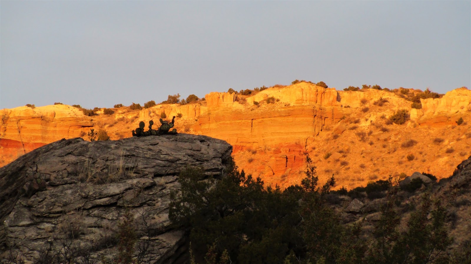
I woke up early once again on day 3 of Winter break 2016. Moosie and Camo were still sleeping while I walked out of camp to get some more early morning photographs. I picked a picturesque boulder field to explore, which included fragile, bright orange dry mud closer to the canyon. This mud created several hoodoos, which are mushroom shaped mud structures with a giant boulders balanced on top. When I saw them, I was instantly reminded of a video I remember seeing a couple years ago of a scout leader and his troop pushing one over in the desert somewhere. Not a good idea.

I returned to camp around 8:00 and Moosie and Camo were packing up. Our plan was to spend a little more time in the canyon and then begin driving west towards New Mexico. After packing up and hiking back to the car, we chose to hike the Chimney Rock trail. It was about 2.7 miles to reach the rock structure, and 2.7 miles back. It was a pretty easy hike, temperatures were just right. The view of Chimney Rock was pretty spectacular, as well as the surrounding canyon. Several other hikers enjoyed the view with us. By the time we reached the car once again, Moosie suggested it would be best if we hit the road soon, since we did not know where we were going to camp that night. Before leaving the park however, we did a quick hike up to a giant cave, and then stopped by the Visitor's Center and read up on some of the history of the canyon.

A couple days before, Camo played a podcast about a hospital in New Orleans during the Katrina incident. The podcast noted how within three days, the hospital had gone from a normal, operating institution into an unfamiliar, wild place with decisions being made that had never been made before in regards to the life and death of the patients in the building, all due to the conditions of the city after the hurricane. I joked that the same is true on the trail, that on the third day, we begin to become feral once again. By the time we left Palo Duro, I was beginning to feel feral once again, and I liked it.

We decided to set our sights on Ute Lake State park in New Mexico to spend the night. While driving west on 40 near Amarillo Texas, We spotted Cadillac Ranch by chance. Of course we had to turn around and get a few pictures. There was a steady stream of tourists arriving and departing the 15 minutes or so we were there.

We reached New Mexico late in the afternoon, not long after Camo struck a giant piece of metal lying in the middle of the highway, denting and damaging the exhaust below the car. The landscape began to look more wild, the plains dotted with cactus and juniper, more canyons opening up in the land. I felt very happy to be back. Temperatures were dropping and a cold wind blew across the desert. After taking some incredible wide open back roads, we reached Ute Lake State Park around sunset. Other than a few RV's, the park was pretty much empty. The small town of Logan was a few minutes away, and Camo suggested we head into town for dinner and some beer. Moosie and I cheerfully accepted that idea, and before long, we were in a nice warm brewery, drinking and eating our fill, and sharing trail stories. The night would be a cold one, Moosie and I cowboy camped once again behind a brick wall designed as a wind break in our campsite, and the next day we would begin heading towards Bandelier National Monument a few hours away...

Wednesday, January 4, 2017

Palo Duro Canyon (Texas): Winter Break Day 2


Early morning sunrise


Morning camp

Camo finding his way up the canyon


Camo and Moosie find clean water in the canyon


Pictographs

A Prehistoric kitchen used for grinding food

Hiking south

Miles and miles of canyon privately owned. This was as far as we could go in the park.

Sunset


Camp for the night
I woke up the next morning early. Day two in Palo Duro Canyon had begun. I think I was still on Maryland time as my body naturally woke up an hour before sunrise. Moosie and Camo were still sleeping so I decided to look around the area and take some sunrise photographs. I slept pretty comfortably and peacefully during the night. When camping, I never know what to expect. My dreams can be pretty vivid, and many times somewhat traumatic. I had many nightmares while hiking the Appalachian Trail last year. Later in the morning, Camo commented on having a vivid, stress filled dream.

While taking my morning stroll, I was thinking about the book "Empire of the Summer Moon: Quannah Parker and the Rise and fall of the Comanches, the Most powerful Indian Tribe in American History." Palo Duro Canyon was a favorite winter camp ground of the Comanches and the site of the last battle between the United States Army and the remaining Comanche tribe before being escorted onto the reservation in Oklahoma. The book describes in detail the trials and tribulations of General Ranald S. Mackenzie and his troops to hunt down, and eventually surprise attack the remaining Comanche Indians wintered down in Palo Duro Canyon, who were led by their last great chief Quannah Parker. Mackenzie and his men killed only four Comanches after marching down the walls of the canyon, but destroyed most of their winter lodges, supplies and killed over 1,000 Comanche horses. This was the final blow which led to a Comanche surrender. Without their horses and supplies, the Comanches could not continue their resistance and way of life.

While the sun was rising above the horizon, I tried to imagine the scene. Did Mackenzie and his troops come down the canyon walls where we were now camped? How many Native Americans camped where we now found ourselves? The canyon has been used over 10,000 years by various Native American tribes, are there any signs of their presence on the rocks and grounds nearby?

By the time I returned to camp, Camo and Moosie were finishing their breakfast and packing up. We decided to spend the day bushwhacking up a random side canyon. Camo immediately took a high route and found himself way up on the surrounding cliffs. I was about midway up and traveling across sketchy, steep washes. Moosie, perhaps the most wise, was traveling along the canyon floor, where eventually Camo and I would meet her. We continued up the canyon for a few hours before turning around due to time. The entire canyon appeared as if it could completely wash away in a single rain storm. There was evidence all around of traumatic water movement, where flash floods appeared to destroy parts of the canyon sweeping down tons of mud and large boulders.

By afternoon, we decided upon another place to camp. We still had an hour and a half of sunlight left so we decided to get one last quick day hike in. We walked as far as we could along the Prairie Dog Town Fork of the Red River before reaching the park boundary and barbed wire fences of private property. There were still miles and miles and miles of canyon beyond those fences. Camo, Moosie, and I soaked in the serene scene before us. By the time we returned to camp the sun was already setting. I wondered what the night would bring. General Mackenzie's slaughter of the Comanche horses had spawned a legend: A phantom herd could be seen riderless, galloping through the canyon, their hooves kicking up red soil along the trails. Would we hear them in the night? Would they appear in our dreams?

Tuesday, January 3, 2017

Palo Duro Canyon (Texas): Winter Break 2016 part 1


Town of Quannah

Palo Duro Canyon

Myself, Moosie, and H2Camo

My old Appalachian Trail friends H2Camo, Moosie and I decided to get together for winter break this year. It's been just over a year since the three of us finished the Appalachian Trail together. After some discussion, we decided to head to Texas and New Mexico to do some hiking. Moosie and I work in public schools in our respective areas, and Camo is in grad school in Texas, so the timing worked out perfectly to get together for a week.

Moosie suggested we check out Palo Duro Canyon which is located in the Texas Panhandle. It is considered the Grand Canyon of Texas. I was very excited about this suggestion because I just finished reading the book "Empire of the Summer Moon: Quannah Parker and the Rise and Fall of the Comanches, the most Powerful Indian Tribe in American History." Palo Duro Canyon was a favorite winter camping area for the Comanches, and the site of their final battle with the United States Army before being forced onto the reservation. The book follows the story of Quannah Parker in particular, the mixed-blood Comanche who became their last and greatest chief. The book was a real eye opener, and I found myself at times identifying with the plight of the Comanches, as well as the Texas frontier settlers, and with the army generals. What would I do if I were in their shoes? The brutality the two sides waged against one another was shocking, the original size of the Comanche empire was staggering to comprehend (240,000 square miles), and the outcome of the culture clash left me feeling battered by the time I finished the book. Visiting Palo Duro Canyon and driving through the Texas plains allowed me to visualize various scenes in the book, and connect to some of the characters.

Moosie and I took planes and arrived in Dallas on the 26th of December. Camo picked us up at the airport. After spending the night at Camo's parents house, we were off first thing in the morning. It was about a six hour drive from Dallas to Palo Duro. Looking out across the Texas landscape, it was hard to comprehend the size of the place. Once we reached the plains, it was a little easier to imagine buffalo once wandering in huge herds across the grasslands. Mostly I remember looking at the occasional ranch, and the giant wind powered windmills along the highway. Moosie, Camo, and I caught up on life after the trail, listened to music, and several episodes of Radiolab. The open skies, warm air, sunshine, and good friends were just what the doctor ordered at this time.

We reached the canyon an hour or so before sunset. We secured backcountry permits for two nights. Shortly before dark, we began our hike into the canyon. The canyon is 120 miles long, and we would see just a sliver of the place. It felt great to put the backpack on again, and walk along the trail. Moosie, Camo and I followed the Prairie Dog Town Fork of the Red River, the waterway responsible for the carving of the canyon. It was one of the strangest rivers I have ever seen, looking like a muddy irrigation canal more than a river, thinly slicing through the canyon. The ranger told us not to drink the water as it contains waste from the nearby town of Amarillo. By the time the sun set, we were still looking for a place to camp. We decided to climb up from the floodplain and the cottonwood trees and camp amongst the junipers, prairie grass, and cactus. We found a nice spot with a juniper windbreak, and the three of us chose to cowboy camp under the bright stars.  Day one was coming to a close and I couldn't have been happier to be where I was...