Sunday, January 31, 2010

Jan. 31, 2010

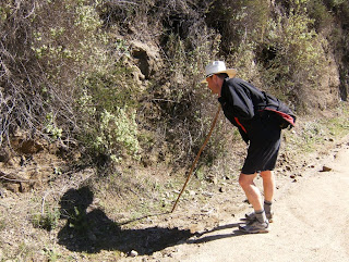
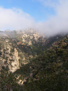
I went for a morning walk in the Verdugo's up the fire road from the south side. It looks like they brought in the heavy machinery this past week to perhaps level out the fire road. After last week's rain, the road suffered from erosion and small rock slides. There were some new arrivals on the scene this weekend...


Ceanothus bushes dotted the hillside (above)

Two tone everlasting (above)

Sugarbush (above)
Castor bean (above)
Mt. Thom (above)
Bush monkeyflower (above)
California lace fern (above)

Lupine (above)


Twiggy wreathplant (above)

I love crossing paths with new specimens. This one is called Western Peony (above).

It's amazing how much one can miss, even while walking. I stopped and dropped my backpack for a minute to take a drink of water. When I bent over to pick it up, I looked at this beautiful Black Sage blossom that I definitely would have missed had I not been thirsty.

Permits Now Required for Half Dome

I wonder if the weekend I took this picture last August had anything to do with the decision?

Friday, January 29, 2010

Free Parking: A Thing of the Past?

I heard about this news report on the drive home from work today.

I'm all for protecting the environment, wild places, clean air etc., but not at the price of the people. What's in it for us? More parking tickets? Smaller bank account? Loss of the personal freedom driving a car provides?

The people need a reason or an incentive to "buy into" environmental legislation that severely alters a way of life. Sure the city is rewarded with incentives, but what about the common man/woman? Punishing the people economically just creates anger and resentment and bitterness towards the movement, even if it does clean the air, reduce pollution, and minimize traffic.

Or is it all about the money?

Wolf Moon 2010

Wolf Moon 2010.

Wednesday, January 27, 2010

Fresh Air

Another rainstorm passed through the area yesterday afternoon, which put in place fresh, clean, clear air from the Pacific today. I had a couple of hours in between work assignments so I took a quick walk in Griffith Park. It's interesting, after last week's rain, it seems to have reset plant growth. The wildflowers from the fall seem to have been washed away, and those who jumped the gun and began blooming early, also seem to have met their demise. In their place is a lush green carpet, that will last just a few months before the summer heat and drought will turn it all brown again.


Chickweed (above)
Canyon sweet pea or American vetch? (above)
Just before I concluded my hike this afternoon, I crossed paths with this fantastic specimen on a hillside, hiding amongst the bushes.

Sunday, January 24, 2010

Verdugo with Pete

My biologist/botanist/buddy Pete came up to visit this weekend from San Diego. We decided to take a hike in the Vedugo's this morning, to "work out the toxins" after spending the night before hitting the town. Pete knows his plants, and it was great to absorb some of his knowledge about the local vegetation.
California dodder (witch's hair above)
While spending some time sitting atop Tongva Peak, we were greeted by a small hiking party of five fellow hikers. While they ate their lunch a few feet away, Pete and I continued our conversation. At one point, Pete decided to show me an interesting device he uses at work, a wind gauge. I noticed while Pete was showing me the instrument, that the conversation from the group of five suddenly came to a halt, and I could feel their gaze upon our backs. Pete and I soon figured out why. They were fellow geek hikers!

Golden yarrow (above)
After Pete showed me the wind gauge, I asked one of the hikers if they knew any of the names of the snow covered peaks to our east. (I've been dying to know for well over a year now. Every time I drive to work in the morning, I look at the peaks and try to figure out which ones they are. I've never really known for certain, and it's been driving me crazy!) Anyways, one of the hikers quickly jumped to his feet and his girlfriend exclaimed, "Start with Mt. Wilson!!" The hiker pulled out his I-phone and pulled up the topographic maps of the area and proceeded to list them off for me. I'll try to relay the info, starting from left to right:

Strawberry Peak, Mt. Lawlor, Mt. Disappointment (the flat one to the left of San Gabriel Peak), San Gabriel Peak (the highest of the peaks pictured), Eaton Saddle (the dip on the right), Occidental Peak, and Mount Wilson (on the far right, actually not pictured).
Mt. Disappointment is an interesting peak. The top was flattened to install a Nike missile system in the 1950's.
White nightshade (above)


Overall, it was a good day to get outside and get some exercise. It was great to hike with Pete as well.

Saturday, January 23, 2010

After the Storm

Snow in the San Gabriel's.

I went for a brief hike this morning before work, after a week of heavy rain.

Here's a view looking northwest. I'm assuming the snow capped mountains in the distance belong to the San Rafael Mountains.


Friday, January 22, 2010

Sunday, January 17, 2010

Inspiration Point (San Gabriel's)

Sweet alyssum (above)

I took a hike up to Inspiration Point point today before the rains set in. It was nice to hike in the San Gabriel's again even though this particular hike was unlike most of my previous excursions in this mountain range. There were tons of people on the trail. In fact, I think this was the busiest trail I've been on since I first started hiking in Southern California a year and a half ago. With it's popularity, come all things human unfortunately: Plastic bottles and aluminum cans in bushes, candy wrappers on the trail, spray paint on rocks, and worst of all, used toilet paper stuck to thorny bushes and plants. Not that it was everywhere, but just enough to want to say, "Come on people!!!"
I'm not quite sure why this trail is so popular. I'm guessing it's because of it's proximity to Pasadena. Perhaps since most of the National Forest is still off limits due to the Station Fire, this trail has seen an increase in traffic. Perhaps its due to the area's history. I can't say for certain. One thing is for certain, the trail offers a great workout.


Rosemary (above)
Before hiking up to Inspiration Point, I took a side trail up to a ridge that passed several historical markers describing the Mount Lowe Railroad. It's crazy to think how much work went into building the railroad only to have it destroyed by one natural disaster after another.
Speaking of natural disasters, the fire line from the Station Fire also was clearly visible at the top of the ridge. One side of the mountain was completely scorched, while the other side escaped unscathed.


The Echo-phone (above).


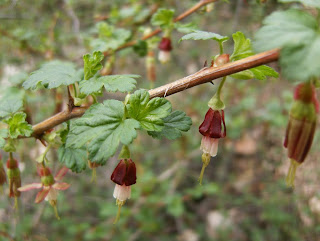
Hillside gooseberry (above)

Despite the random screams and hello's from the echo-phone, the hike to the Point was rather enjoyable. The crowds thinned out, the trail steepened, and the vegetation took on a wilder appearance.


Once I reached the top of the ridge, the fire line was once again visible. Looks like Inspiration Point barely dodged the bullet. There wasn't much to see today through the fixed telescopes except the looming storm clouds preparing to dump up to 20 inches of rain in some parts of the mountains this week. Looks like it will be an interesting week, especially in the burn areas.
View towards Mt. Wilson (above).

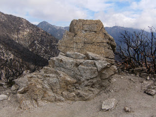
Easter Rock (above)

Crimson spot rock rose (above)